


Review Highlights

“The entrance is marked by a yellow gate with a private property/no trespassing sign (more on this later).” in 18 reviews

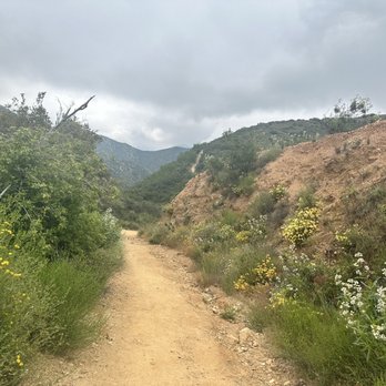
“This is a fun trail that's marked well and is a relatively easier hike because of the steady incline.” in 7 reviews

“Baldy Road, look for the turnout (on both sides of the street) not long after you pass the dam, which will be on your right.” in 7 reviews
Location & Hours

Claremont, CA 91711
You Might Also Consider

in Atv Rentals/tours

in Horse Boarding, Horseback Riding

in Ziplining
Amenities and More
Ask the Community
Q:
Do you have to pay for parking? Also can you go at night?
A:
Park 1/4 mile down from Yellow Gate trail head at big dirt parking lot by San Antonio Dam. Free parking
Will L.3 years ago 1 person found this helpfulQ:
Is it good for infants?
A:
No. Unless you want to carry the infant all the way up
Will L.3 years ago 1 person found this helpful
Recommended Reviews
Overall rating
141 reviews
5 stars
4 stars
3 stars
2 stars
1 star
- May 29, 2023
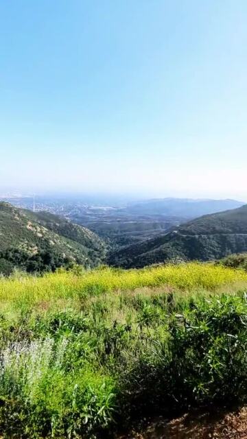
After our hike today, I can say this is going to be one of our favorite hikes. There are lots of parking along the road and we walked to the entrance. The trail is clear and easy to follow. These yellow flowers along the trails smells so sweet. Steady incline, not so rocky, weather today was perfect. We took our time and stopped couple of times to rest. It was 4.6 miles round trip, 1400 ft elevation, took us about 3-1/2 hrs because we took a lot of stops. There were lots of people on the top just enjoying the view and having snacks. We took couple of pictures and then head back down. This is easy to moderate hike.


 Helpful 1
 Thanks 1
 Love this 1
 Oh no 0
  4675401293Feb 11, 2023
Lovely hike, especially after weeks of rain. There is a moderate incline most of they way up to the top and there is a decent amount of shade as well. RT I logged about 5 miles.
Parking here is ok; I parked along the pull out which felt sketch but worked out.Helpful 5Thanks 0Love this 4Oh no 0 Lorraine B.Walnut, CA36216678Aug 23, 2023
This was tricky to find but easily became one of my favorites! It's a pretty easy hike; there's a gradual incline at the beginning while your body is still warming up so it feels a little hard, and incline at the end but your body is warmed up by then and it feels like nothing. Between that it's just good views and a fun hike! I highly recommend !


 Helpful 4Thanks 0Love this 0Oh no 0
 David Keith C.Loma Linda, CA024152May 17, 2023
No sign where the trailhead starts was a pain. It took me like 30 mins to go round and round to find it. I eventually found it on YouTube.
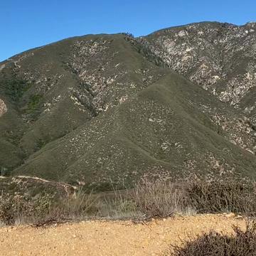
The trail itself was fun. It was steep, but not that steep. Well, up until the very end it got pretty steep for a beginner/mid hiker level. There was a little stream (maybe a river) which was calming. Overall, it's a pretty good trail with a good view in the end.Helpful 1Thanks 1Love this 1Oh no 0 Anissa B.La Puente, CA081Feb 17, 2024
Cars get broken into here. Unfortunately not good parking either. No parking rangers to check on cars. The hike itself is great but the fact that people do scandalous things like breaking into cars is very unfortunate.
Helpful 2Thanks 0Love this 0Oh no 0 Sierra G.Upland, CA02011Nov 27, 2023
Such a breathtaking hike! It is so much fun & well worth the hard hike. It takes about an hour & a half to go up & down!
Helpful 0Thanks 0Love this 0Oh no 0- Feb 9, 2021
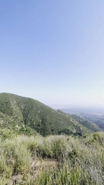
Super fun hike with great views, especially from the top! I found this to be an extremely pleasant hike - it's a mostly gradual incline, lots of shade, wide trail, polite hikers - very decent. The ground is rocky and uneven a lot of the way but it's definitely very manageable. We went 5.4 miles and gained 1224 feet and we spent about 3 1/2 hours doing it very leisurely - I take a lot of photos and we spent a lot of time at the top having fun so it adds time on.
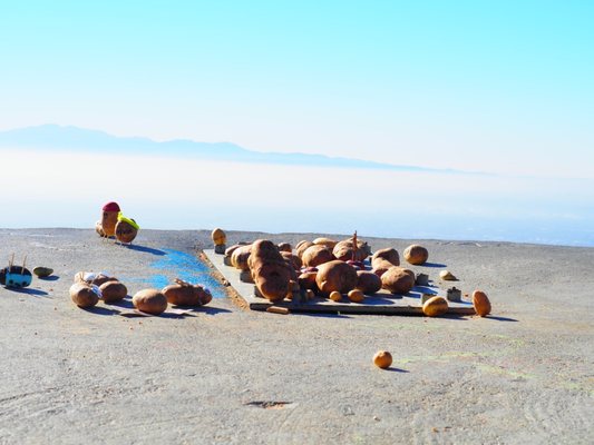
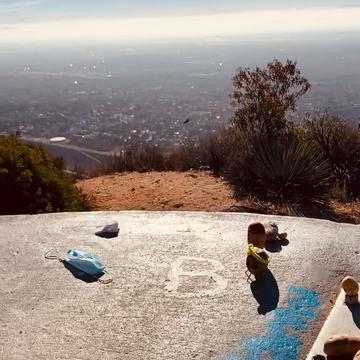
AllTrails calls this hike moderate and I think that's accurate. There are spots where the incline can be intense, but for the most part it's gradual. I'd say this trail is probably about 60-70% shade as well. And along the first mile or so, you can hear a nice flowing stream down in the ravine! At the top there's a raised, circular cement area where everyone places their potato offerings lol! We brought a potato and decorated it to mark the occasion lol! Super fun! There used to be a cool sign at the top that you could take a picture with, but sadly it was gone - apparently it was there last week so not sure what happened.
The trail is very heavily trafficked. Tons of hikers, a few mountain bikers, and even a crazy unicycler skirting the rim of the trail!! We got there at around 730am on Sunday and it was already packed. By the time we got back to the car around 11am, parking was already 3 rows deep and becoming hard to find (see my pics). There's plenty of room for social distancing and most of the hikers aren't wearing masks which is not an issue for me but if you're at all scared of this kind of scenario, don't do this hike.
For the most part, the hikers and bikers (and unicycler lol!) are polite and respectful. There's a little graffiti along the trail sadly. And we really only had one weird encounter - a woman pulled her pants down and peed on the trail - yes, the actual trail right in front of us - no modesty, no cover, just naked and peeing on the trail and left her toilet paper right there too. I was shocked and appalled to say the least lol. But this is LA and a very packed trail so just be aware you might get some weird stuff going on.
The trailhead has signs saying "no public access" and "no trail access". I knew that before coming and tried to research but still don't know why, bc everyone enters here. I'm guessing maybe they just don't want anyone parking there. At the entrance, there's a yellow gate across the trail, but there's a hiker entrance opening just to the left, like so many other trails out here so it must be allowed. Not to mention that there are TONS of hikers entering. Parking is in a gravel lot about 1/4 mile away. After you park, you have to walk along the road and it's a little scary bc there's a lot of fast traveling cars and such - so just be careful. Also, there are no bathrooms.Helpful 21Thanks 0Love this 19Oh no 0  240852808Jan 5, 2021
I visited Potato Mtn on Jan 2021 and wanted to share my tips from the hike!
PROS
1) moderate hike and a majority of the hike is shaded by trees. Less shade obviously as you get higher to the top.
2) the hiking trail is fairly wide, which is great during covid times.
3) Bring your own potato to leave at the shrine if you wish!
4) roundtrip is ~5.5 miles and took about 2 to 2.5 hrs. Elevation gain is ~1300ft.
CONS
1) This is just a warning, but if you google map "potato mtn trailhead", it will take you to an unmarked trail head entrance with a no public access sign (refer to photo). Despite the signage, many people still use the trail. I can confirm that the trail does lead to the potato mtn summit. About 0.2miles before the entrance on google map, one will bypass a giant dirt parking area, which is where one will park. Be careful walking to the entrance as there is NO pedestrian walkway or bike path. If you've walked to the "welcome to Angeles National Park sign, you've walked too far. The trail head entrance should have a yellow gate. As a visitor to the area, this weird entrance threw me off, but I sorta followed the crowd lol.
Enjoy the hike and the views!Helpful 11Thanks 0Love this 4Oh no 1- Nov 18, 2021
I recently went on this hike with my hubs after having it bookmarked for years. We parked at the North lot of the Claremont Hills Wilderness Park on Mills Ave because I knew our car would be safe there from vandalism- the Claremont park rangers are frequently patrolling the lots. I do NOT recommend parking on Mt. Baldy Rd- first, it is a no parking zone so you can get cited for a $50 ticket, second, tons of traffic accidents happen between pedestrians and vehicles all the time, and lastly, your car has a a very high likelihood of getting broken into. I highly recommend paying the $5 on weekdays or $7 on weekends and park in a safer lot for your own peace of mind.
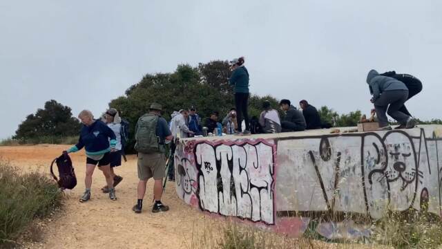
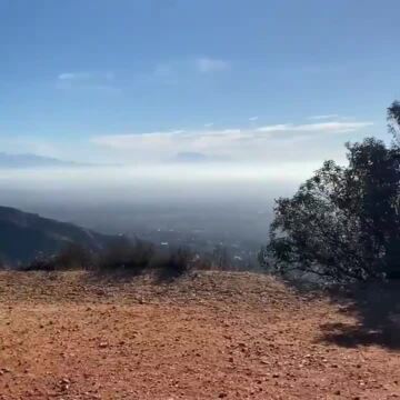
Once you enter the loop, it will add 5 miles to your hike- bringing the total to around 9 miles. As you walk-in you'll come to a fork that splits to the left and right, labeled Burbank Canyon Mtn Way (left) and Cobal Canyon (right)- take Cobal Canyon. You can take Burbank, but it'll add more miles and time to your hike. You'll hike through a shaded area for around 0.50 miles, and after that, it'll be full sun, no shade for almost the rest of the way. Once your up about 1.5 miles, you'll see a yellow gate with a sign stating you're leaving the CHWP and entering Evey Canyon. It'll list Potato Mtn. You'll go through that gate. Then it's a steady incline and there are clear signs along the way to help you navigate. It is a rocky hike, and once you leave the loop, we had the trail pretty much to ourselves on a weekday. Once at the top, I was sad to see graffiti- next time I'm bringing spray paint to paint over it. The views made up for it though. I was able to see all the way to downtown LA and beyond. If it wasn't for the smog, I bet I could see all the way to Catalina Island. We didn't bring a potato. I wish I had brought a small picnic- like sandwiches to eat once you're up at the top. Of course, practice good hike etiquette- pack your trash out, never leave any garbage behind. The trail was pretty clean so I think many are following the etiquette.
Note: Wear a hat, whatever sun protection you want, sunblock, and bring plenty of water. Once you pass the gates at the loop, there is no water source. If you bring your dogs, bring lots of water for them as well. The park rangers have mentioned dogs have died in their Wilderness park due to careless owners not bringing enough water for their dogs- don't be that person- it'll be devastating for you and a sad way to go for your fur babies. Don't forget- it is way hotter for
your dogs to be lower to the ground, combined with fur, and no way to sweat. Truthfully, I don't recommend this hike for dogs. Please keep that in mind. I didn't bring my dogs because 9 miles is way too many miles for my Shibas in full sun, along with knowing there'll be rattlesnakes, tarantulas, bears, coyotes and mountain lions. If they were to get a snake bite, it wouldn't look good. The park rangers patrol just the Claremont portion. Potato Mtn is in the Angeles forest and a different jurisdiction- and the trail is not able to accommodate vehicles easily as some parts are too narrow- most like you'd have to be airlifted out.
Wear shoes with traction, as the trail is kind of rocky. I brought hiking sticks to help with the downhill. Weekends will def be busier. There is poison oak so try to keep your hands off any three leaf plants. If you mountain bike, this trail isn't for the novice biker. You'll reach some serious downhill speed. I saw one mountain biker and the hill was so rocky and steep at one point he was walking his bike up. I would hike it first to see if you think you can bike it. Since it is shared with hikers, they'd be in the way. I like mountain biking in designated mtn biking trails like in Moab, Utah.
Anyway, enough of my tips on safety. I heard what happens on these hikes so I want to make sure everyone stays safe and enjoy it the fullest. This is a fun trail that's marked well and is a relatively easier hike because of the steady incline. Still kicked my butt. I would say it is an intermediate level hike, def not a beginner hike. If you are out of shape, this hike will be hard. Don't listen to the reviews saying this hike is easy. Combine the hike with the usual SoCal heat and it'll be challenging. It is not a beginner's hike, the downhill is steep and will be hard for anyone with knee issues. Going up will burn the heck out of your booty. It is a good workout hike, but not for those who don't really workout. Helpful 5Thanks 1Love this 2Oh no 0


You Might Also Consider

in Boat Parts & Supplies, Boating, Boat Repair

in Motorcycle Rental, Atv Rentals/tours