


Location & Hours
Johnsville, CA 96103
You Might Also Consider

in Fishing, Whale Watching Tours, Boat Charters
Amenities and More
Recommended Reviews
Overall rating
5 reviews
5 stars
4 stars
3 stars
2 stars
1 star
 Dale G.Reno, NV125600898Aug 4, 2014
To get there: You can turn from CA-89 onto Johnsville Rd. and it is approximately 4.6 miles to Jamison Mine Rd on the left. The trailhead parking area is 1.3 miles from the turnoff.
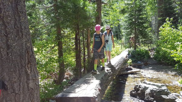
The trail: From the parking area you'll see the trail and you'll go up to an old mine building and the trail goes to the left. The climb is moderate but partially shaded. If you go to Jamison and Rock Lakes you'll have an elevation gain of about 1100' to 1400' depending if you make it a loop and check out Wades Lake. We ended up exploring different areas and clocked 9.15 miles.
This trail is extremely rewarding with a good workout, beautiful views, excellent cool lakes to swim in, and friendly people. Helpful 2
 Thanks 0
 Love this 3
 Oh no 0
 Tracy S.Tucson, AZ333689633Jul 13, 2010First to Review
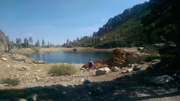
This trailhead can be reached in two ways--by driving down a dirt road BEFORE the entrance to Plumas-Eureka SP, or by hiking to it from Upper Jamison Creek CG, INSIDE of the park. Either way, you will end up in a flat, gravelly parking area near several old mining buildings. This trail will take you to three lakes--Grass, Rock, and Jamison--and also leads deeper into the Lakes Basin Recreation Area if you are looking for a longer hike.
The start of this trail is just miserable. A treacherous, rocky uphill scramble past lots of old mining stuff. Push through it, though, and after the initial climb the trail becomes far more scenic. Early in the season, much of the trail will be underwater, but all of the creeks and streams make for a very pleasant hike. Past Grass Lake, though, snow lingers until early July, so be careful.
Although this is a beautiful hike, it really needs some TLC. There were several downed trees blocking the trail, including one that landed right across a log-bridge, making the creek crossing very treacherous. Hopefully the forest service will do some maintenance soon.

 Helpful 1Thanks 0Love this 1Oh no 0
 Lisa M.Larkspur, CA225123May 27, 2015
Plumas-Eureka State Park is a jewel in the crown of CA state parks and this hike is the crown jewel.
Work off breakfast by walking up to Grass Lake. Continue on to Jamison Lake and then Rock Lake. Extra bonus points for going to Wades Lake.
Beautiful sights. Glute-kicking hike. Sit on the smooth granite overlooking Jamison Lake and reflect on the beauty.
Helpful ranger and staff at the park headquarters.
Well kept secret area, but go support the park and community. GO!Helpful 1Thanks 0Love this 1Oh no 0 Kym G.Antelope, CA74Jul 15, 2012
Clean trail. Tough in the beginning, esp. backpacking with 4 and 6 yo kids. Beautiful scenery. Husband got a leech on his leg swimming in Grass Lake. Ruined swimming for the rest of the trip at Jamison Lake. Mosquitoes and biting flies impervious to deet bug repellent. Backpacking sites are all imperfect - too small or no shade or uneven.
Helpful 0Thanks 0Love this 1Oh no 0 Armed And Safe F.Reno, NV081May 29, 2012
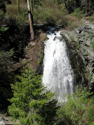
This hike is good uphill exercise. It's beautiful all the way and in the spring you cross a nice mountain creek every 100 yards. Lots of granite and thick ponderosas and ceaders as well as the ocasional flowering vegitation. I give it 4 stars because I've been to Yosemite a few times. 4 stars mean it's worth the trip, especially if you're in the area. Their are many lakes to visit. My favorite is Rock Lake. great for swimming and jumping of rocks. I even have a story of a fish that I had to swim after to retrieve. It was still attached to the stringer or else I wouldn't have even tried. Take the trail about 5 miles (+/-) and be on the PCT. When you're done drive to HWY 49 for rivers and waterfalls, or come to Reno and get your CCW from us. It's better than blowing your $$$ at the casinos.
Helpful 0Thanks 0Love this 0Oh no 0